Listen to a song about two teens from different towns of Banteay Meanchey flirtily teasing each other as you learn about the province.
In the northwestern corner of Cambodia, where ancient Khmer highways disappear into rice plains and modern trade routes flow toward Thailand, lies Banteay Meanchey — one of the country’s most historically layered, geographically fascinating, and culturally underrated provinces. Most travelers know the province only through the border city of Poipet. Yet beyond the casinos and highways stretches a vast frontier landscape shaped by empires, prehistoric seas, ancient reservoirs, sacred temples, forgotten roads, silk traditions, and resilient communities.
The name itself already tells a story. “Banteay Meanchey” (បន្ទាយមានជ័យ) translates roughly as Victorious Fortress. The province is filled with ancient banteay — Khmer fortresses and temple strongholds built before and during the height of the Angkorian Empire between the 9th and 13th centuries. These structures once guarded the empire’s western frontier and connected Angkor to territories extending deep into present-day Thailand.
The Western Frontier of the Khmer Empire
During the height of the Khmer Empire between the 11th and 13th centuries, Banteay Meanchey formed part of one of the empire’s most strategic frontier regions. The Khmer Empire was not confined to modern Cambodia. At its peak, it extended across large portions of mainland Southeast Asia, including parts of present-day Thailand, Laos, and Vietnam. To maintain such a vast territory, the empire relied on a sophisticated network of fortified settlements, highways, reservoirs, bridges, and administrative centers.
Banteay Meanchey stood directly along this western corridor. The concentration of fortress-temples throughout the province demonstrates how important the region was to Angkorian defense and communication systems. These fortifications protected the empire’s western approaches while securing trade, religious pilgrimage, military movement, and regional governance. Unlike isolated temple ruins hidden in jungles, many of these sites remain deeply integrated into local life today. Villages, rice fields, and modern roads continue to surround ancient Khmer infrastructure, creating an extraordinary continuity between past and present.
The Ancient Roads of Angkor
One of the most extraordinary aspects of Banteay Meanchey is that the province still preserves traces of the Khmer Empire’s ancient transportation network.
Beginning particularly during the reigns of Suryavarman I, Suryavarman II, and Jayavarman VII between the 11th and 13th centuries, the Khmer Empire developed one of Southeast Asia’s most sophisticated systems of royal roads. These highways connected Angkor to major frontier cities and religious centers throughout the empire. One of the most important western routes crossed through present-day Banteay Meanchey:
- the road from Angkor to Sdok Kak Thom (ស្តុកកក់ធំ, สด๊กก๊อกธม), connected Angkor to an important religious center associated with early Khmer royal ideology and inscriptions documenting the Devaraja cult — the sacred concept linking Khmer kingship to divine authority.
These roads were not primitive jungle tracks. They were elevated highways built with compacted earth and laterite, engineered to withstand seasonal flooding and support continuous imperial communication. Along these routes stood stone bridges, reservoirs, rest/fire houses (dharmasalas, ធម្មសាលា), hospitals (arogyasalas, អរោគសាលា), temples, and administrative stations.
Travelers exploring Banteay Meanchey by motorcycle today can still follow portions of these ancient routes. In rural areas, old embankments remain visible beneath modern roads while fragments of laterite causeways continue to shape village landscapes.
Most impressive are the surviving Khmer bridges. Constructed from sandstone and laterite during the Angkorian period, many bridges still remain standing after nearly 900 years. Their corbelled arches and naga-lined structures reflect the engineering sophistication of the Khmer civilization. To cross these bridges today is to physically move along the arteries of an empire that once dominated mainland Southeast Asia.
Banteay Chhmar: The Giant of the Frontier
Among all the province’s historical treasures, Banteay Chhmar stands as one of the greatest architectural achievements of the Khmer Empire outside Angkor itself. Constructed primarily during the late 12th century under King Jayavarman VII, Banteay Chhmar functioned both as a state temple and as a major frontier stronghold protecting the empire’s western territories.
The temple complex is immense. Surrounded by a massive moat and outer walls, the site once formed a complete urban and ceremonial center. Giant Bayon-style face towers rise above collapsed galleries while intricate bas-reliefs depict military processions, scenes of daily life, mythological imagery, and naval battles.
What makes this UNESCO World Heritage Site remarkable is not only its scale, but its atmosphere. Unlike Angkor Wat or Bayon, where visitors often move through crowds, Banteay Chhmar remains quiet and largely untouched by mass tourism. Forests slowly reclaim sections of the ruins while local villagers continue to live around the ancient complex much as communities have done for centuries. At sunrise, mist drifts across the moat while the stone faces emerge gradually from the morning light. The silence gives visitors a rare opportunity to feel the emotional scale of the Khmer Empire without interruption.
Archaeologically, Banteay Chhmar is also significant because of its strategic position along the western road networks leading toward Thailand. It served not merely as a religious sanctuary, but as an administrative and military node within a much larger imperial system.
Banteay Torp, Banteay Preav, and the Forgotten Fortresses
While Banteay Chhmar dominates attention, the province contains several lesser-known Khmer fortifications that reveal the density of Angkorian infrastructure across the region.
Banteay Torp (បន្ទាយទ័ព)
Built primarily from laterite during the 12th century, Banteay Torp rises unexpectedly from the flat countryside like an isolated military watchtower. The temple’s vertical form and fortress-like structure suggest that it played both ceremonial and defensive roles. Its weathered laterite blocks and partially collapsed towers create a powerful sense of abandonment. Compared to polished restoration projects elsewhere, Banteay Torp still feels raw and deeply connected to the landscape.
Banteay Preav (បន្ទាយព្រាវ)
Less visited and often overlooked, Banteay Preav, now a ruin, represents the quieter side of Cambodia’s archaeological heritage. Rather than monumental grandeur, the site offers atmosphere, isolation, and continuity with local village life. Together, these fortresses reveal that Banteay Meanchey was once heavily fortified and deeply integrated into the empire’s frontier system.
Banteay Neang (បន្ទាយនាង)
There is no trace of an ancient temple at Banteay Neang, but a pre-Angkorean Banteay Neang inscription (K.1292), engraved on the limestone cave wall, reveals 7th-century Shaivite religious practices. The surrounding countryside adds to the experience. Rice fields stretch outward from the hill, reinforcing the connection between ancient Khmer settlement patterns and modern rural Cambodia.
Left to right: towers of Banteay Toap, ruins at Banteay Preav, pre-Angkorean inscription at Banteay Neang. Photos by Beyond Angkor & AMS Civilization.
Ang Trapeang Thma: Wetlands, Memory, and Survival
Trapeang Thma Reservoir is one of the province’s most emotionally complex landscapes. Today, the reservoir functions as one of Cambodia’s major wetland ecosystems, providing habitat for more than 200 bird species, including the Spotted Wood-owl, Oriental Plover, Greater Spotted Eagle, Comb Duck, Black Kite, Milky Stork, Painted Stork and the Black-necked Stork. It is also a natural habitat for the Eld’s Deer. During migration seasons, the vast open waters and flooded grasslands become alive with movement. Most famous among its wildlife is the endangered Sarus Crane — the tallest flying bird on Earth. Elegant and unmistakable, the cranes move slowly through the wetlands at dawn and dusk, transforming the reservoir into one of Cambodia’s most important birdwatching destinations. Ecologically, the wetlands support migratory birds, fish populations, amphibians, reptiles, and seasonal aquatic vegetation essential to local biodiversity.
Yet Trapeang Thma also holds profound historical weight. The ancient Khmer road system once passed alongside this natural reservoir, integrating water management and transportation into the empire’s frontier infrastructure.
Centuries later, in 1976, the Khmer Rouge regime transformed the area into a massive forced-labor irrigation project. Tens of thousands of Cambodians were ordered to dig canals and reshape the landscape by hand in hopes of creating an enormous agricultural mega-project. Workers endured starvation, disease, exhaustion, and brutal punishment. Thousands died during construction.
Today, the reservoir embodies both tragedy and resilience. Birds now fly over landscapes once marked by immense human suffering, while local communities continue rebuilding life around the wetlands.
Left to right: Ang Trapeang Thma and its bird populations. Photos by Piak Lim and Phearun Birds.
Phnom Srok: The Moated Settlement and Golden Silk
Among the province’s most distinctive districts is Phnom Srok, a place where geography, urban form, and craftsmanship combine into a uniquely Cambodian cultural landscape. Historically, Phnom Srok is notable for its unusual settlement structure. The district preserves traces of an ancient moated urban form resembling defensive and hydraulic city-planning traditions once common across mainland Southeast Asia.
The moat surrounding the settlement was not merely defensive. Like many Khmer hydraulic systems, it likely served multiple functions such as water storage, flood management, agriculture, symbolic cosmology, and urban organization. The geometric shape of the settlement remains visible in the landscape today, giving Phnom Srok a distinct identity compared to surrounding districts.
But perhaps its greatest cultural treasure is its golden silk tradition. Unlike industrial textile production, Phnom Srok silk remains deeply handmade from beginning to end. The process begins with mulberry cultivation. Silkworms feed exclusively on mulberry leaves before spinning delicate cocoons. These cocoons are carefully boiled and unwound into fine silk threads, which are then dyed using traditional techniques before being woven manually on wooden looms.
The resulting golden silk possesses a shimmering quality highly valued in Khmer ceremonial clothing and traditional textiles. The work requires extraordinary patience and precision. A single piece may take weeks or even months to complete. More importantly, the craft preserves intergenerational knowledge carried primarily by village women who continue techniques passed down through families over centuries.
The unique geometric shape Phnom Srok makes this town truely special. What even more special is the natural golden silk of highest quality that earns Geographical Indication (GI) status for Banteay Meanchey Province. Photo: Google Maps & Khmer Golden Silk.
Serei Sophorn: The Historic Heart of the Province and a Land Once Beneath Ancient Seas
While Poipet represents modern dynamism, Serei Sophorn (សិរីសោភ័ណ) — historically known as Sisophon (ស៊ីសូផុន) — remains the cultural and administrative heart of the province. Sisophon developed historically as an important crossroads town connecting Battambang, Siem Reap, and Thailand. Over time, the city became a regional center for trade, transportation, education, and provincial administration.
Unlike the fast-moving border atmosphere of Poipet, Sisophon carries a slower and more grounded rhythm. Morning markets fill with agricultural produce from surrounding districts while roadside eateries serve traditional Khmer noodles, grilled meats, and local desserts. The city’s streets reveal a blend of provincial Cambodian life mixed with subtle Thai influences shaped by geography and historical exchange.
For travelers, Sisophon serves as an ideal gateway into the wider province. From here, visitors can access Banteay Chhmar, Phnom Srok, Trapeang Thma, ancient road networks, and surrounding rural landscapes.
Long before the Khmer Empire emerged, the landscape around Sisophon belonged to an ancient marine world. The mountains surrounding the provincial town — particularly Phnom Bak (ភ្នំបាក់), Phnom Chingchiang (ភ្នំជញ្ជាំង), Phnom Svay (ភ្នំស្វាយ), Phnom Kantout (ភ្នំកន្ទួត), and Phnom Kangva (ភ្នំកងវ៉ា) — preserve marine fossils dating back approximately 250 million years to the Permian or Triassic periods.
These fossils indicate that the region was once submerged beneath shallow prehistoric seas connected to ancient marine systems that covered portions of mainland Southeast Asia. Geologically, many of these hills contain sedimentary limestone formations created through the accumulation of marine organisms over millions of years. Fossilized shells, marine invertebrates, and seabed deposits can still be found embedded within rock layers throughout the area. This gives Banteay Meanchey extraordinary geological significance.
Poipet: Cambodia’s Modern Frontier
At Cambodia’s western edge, Poipet (ប៉ោយប៉ែត) stands as one of the country’s fastest-growing urban centers. Often misunderstood as merely a casino town, Poipet is in reality one of mainland Southeast Asia’s most active border gateways. The city functions as a major trade corridor, logistics hub, tourism gateway, and center of cross-border commerce between Cambodia and Thailand. Modern hotels, entertainment complexes, shopping areas, and transportation infrastructure continue expanding rapidly as the city grows into an increasingly important regional economic center.
For travelers arriving from Thailand, Poipet often becomes the first introduction to Cambodia. The city’s energy reflects a country moving rapidly toward modernization while remaining connected to regional networks of trade and tourism. Beyond casinos, visitors can experience vibrant border markets, international dining, nightlife, and easy access to northwestern Cambodia’s historical sites. Poipet also serves as an excellent starting point for road trips and motorcycle adventures deeper into Banteay Meanchey’s ancient frontier landscapes.
The Living Frontier of Cambodia
Banteay Meanchey is not a province that reveals itself quickly. Its beauty lies not in polished tourism infrastructure, but in layers — layers of empire, geology, memory, resilience, and transformation spread across plains, temples, wetlands, and border towns.
Here, travelers can:
- ride along ancient Khmer roads,
- cross centuries-old stone bridges,
- stand inside forgotten frontier fortresses,
- observe endangered cranes over wetlands,
- discover fossils from prehistoric seas,
- watch silk woven by hand,
- and witness one of Cambodia’s most dynamic border economies.
In many ways, Banteay Meanchey represents Cambodia itself: ancient yet modern, wounded yet resilient, quiet yet deeply alive. For those willing to move beyond familiar destinations, this frontier province offers one of the richest and most meaningful journeys in the country. Within a single province, travelers can experience prehistoric marine history, Angkorian engineering, traditional Khmer culture, and modern border urbanization. Very few places in Southeast Asia offer such layered continuity across both geological and human timescales.
What to Visit?

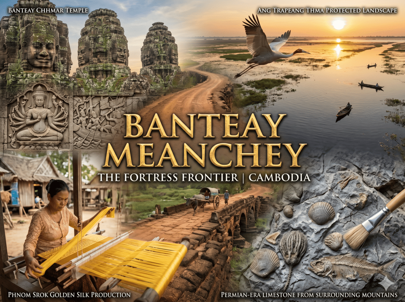
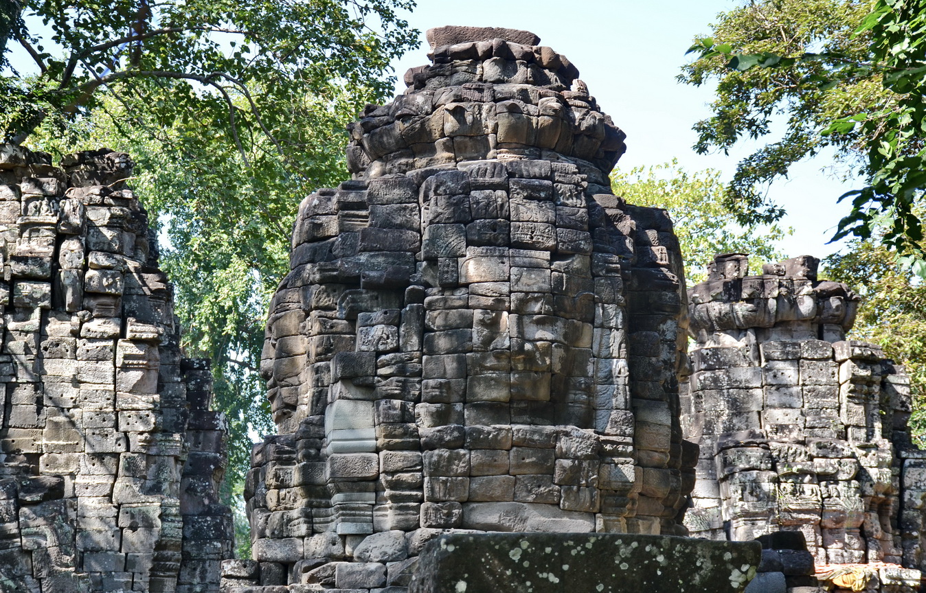
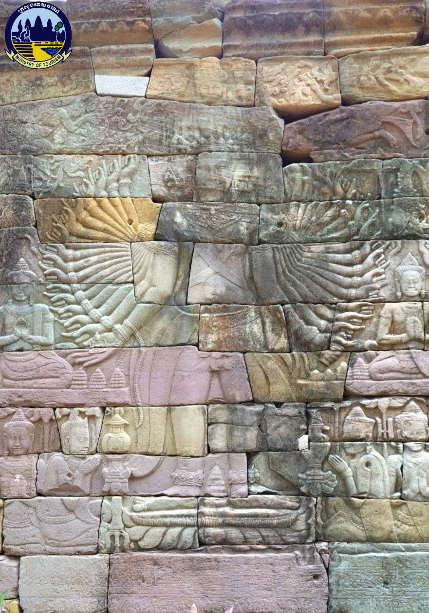
Prasat Banteay Chhmar
- Location: Thma Pouk District
- Entrance Fee: Free
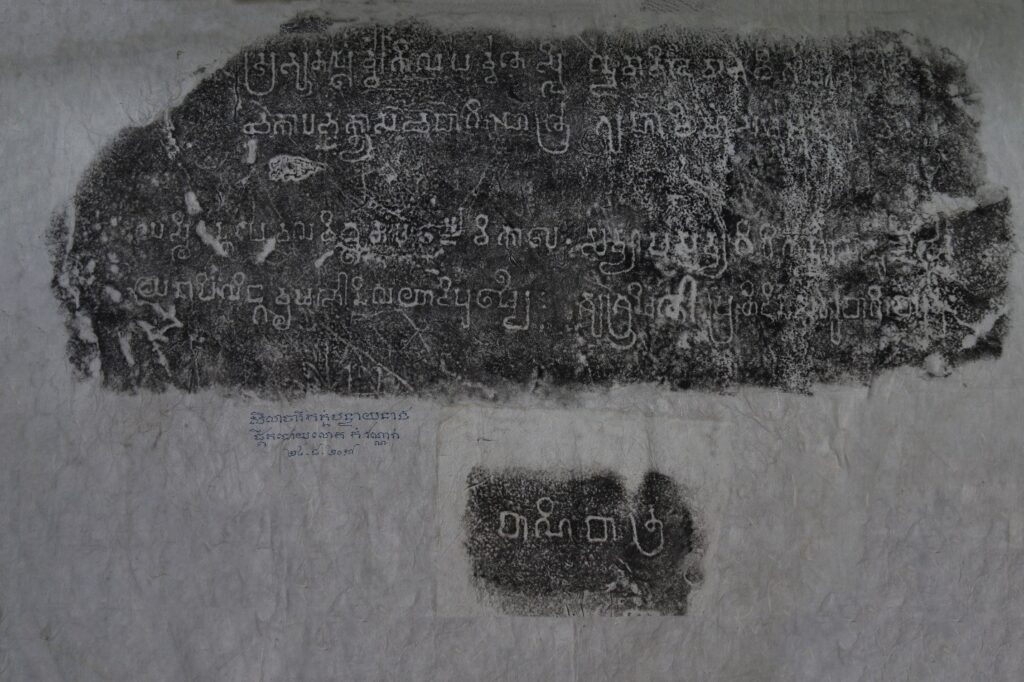
បន្ទាយឆ្មារ is a massive 12th-century complex in northwestern Cambodia that was officially inscribed as a UNESCO World Heritage Site in March 2026. Commissioned by King Jayavarman VII as a tribute to his son, it is the fourth-largest Angkorian structure and is famous for its enigmatic face towers and nearly a kilometer of intricate bas-reliefs. Despite its historical scale, it remains a serene and largely untouched frontier stronghold, offering a quiet, atmospheric alternative to the crowded ruins of Angkor.

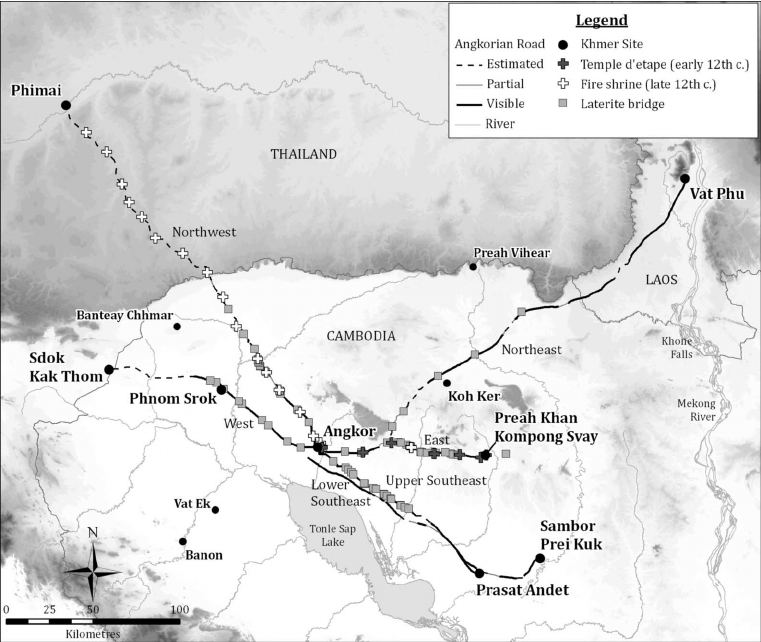
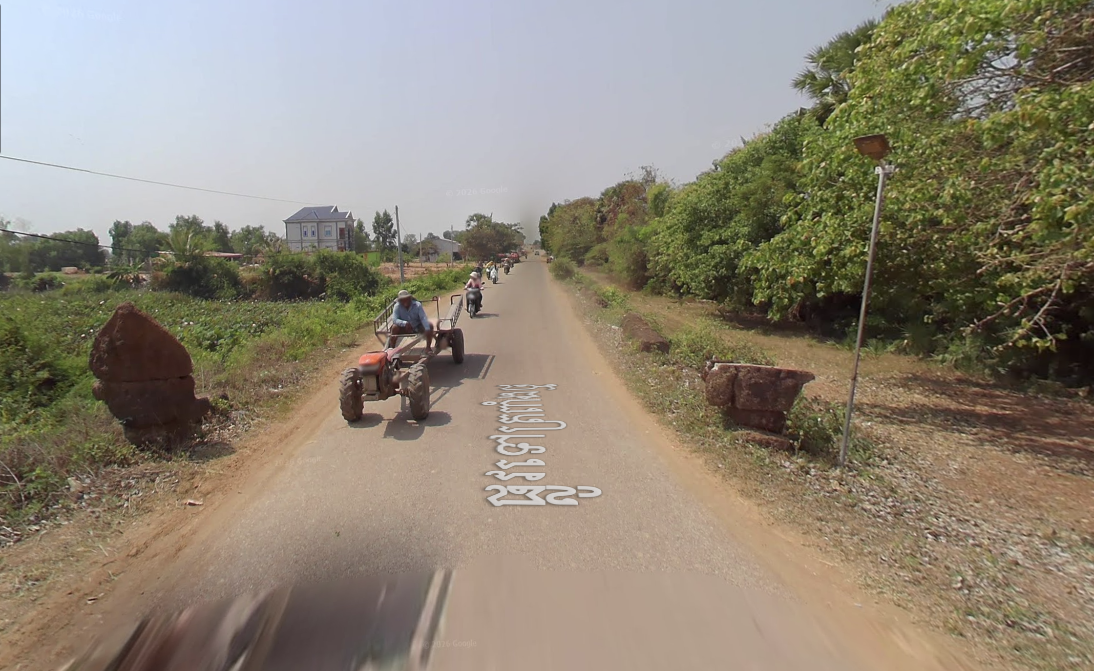
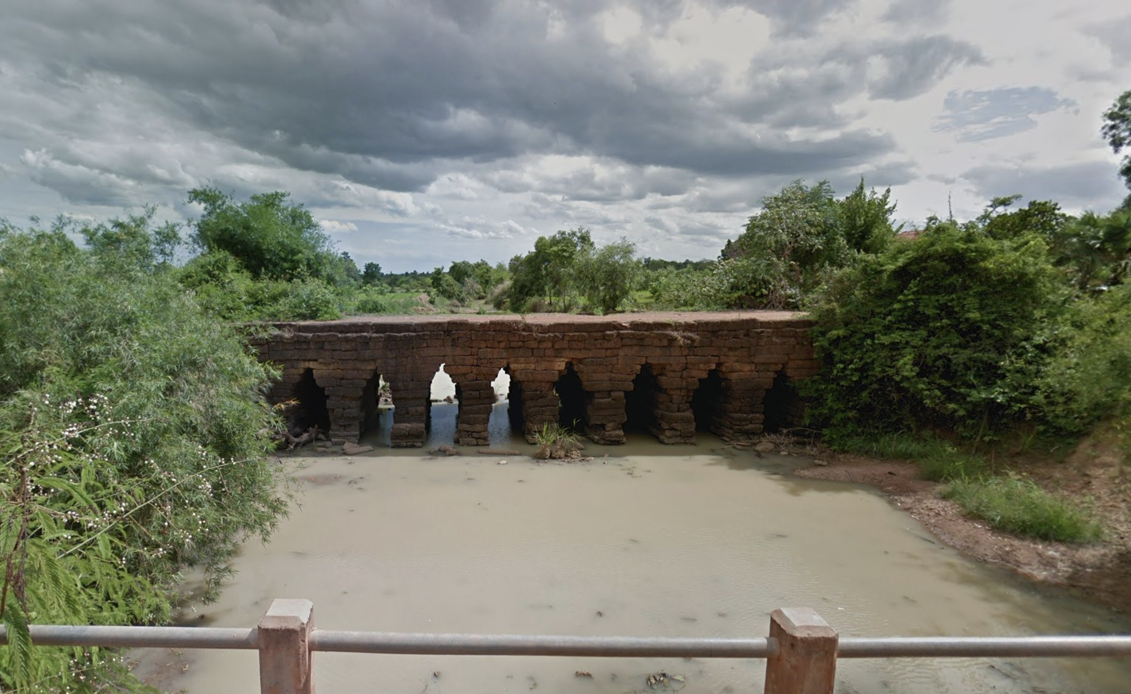
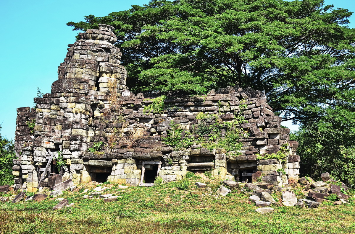
Explore Ancient Roads
- Location: Across the province
- Entrance Fee: Free
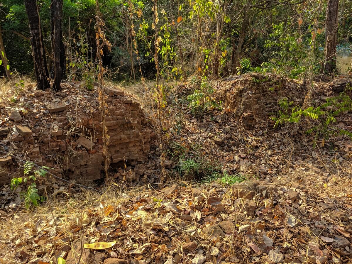
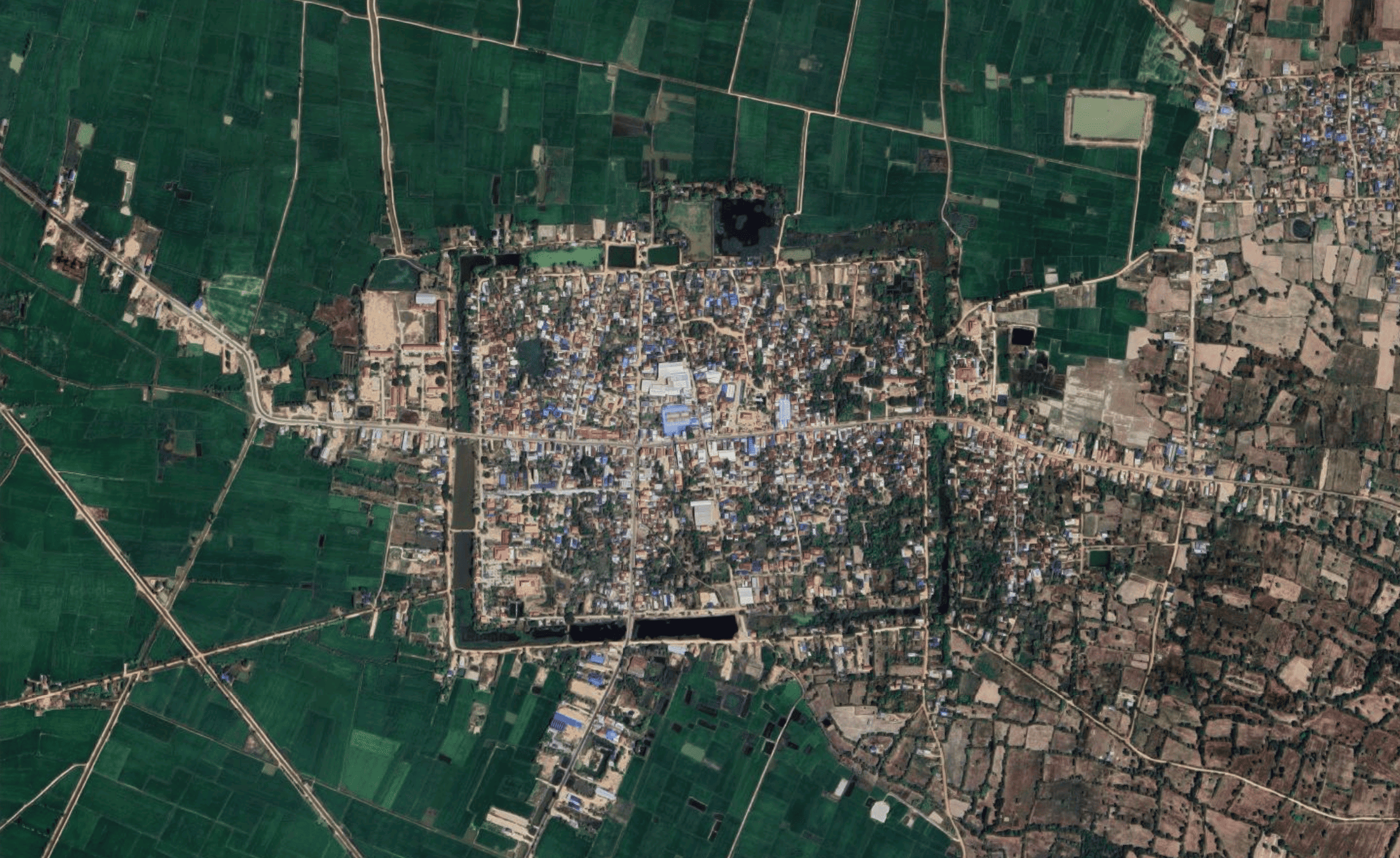
Travel along the primary western highway—the royal roads connecting Angkor to Sdok Kak Thom—to follow the historic arteries that once unified the Khmer Empire. These routes allow you to explore remarkable sandstone and laterite bridges that have stood for over 900 years, still serving as functional gateways across the Cambodian plains. Venturing through these remote areas provides a firsthand look at the rural Khmer way of life, where traditional villages and rice farming remain seamlessly integrated with the landscape of ancient ruins.

Ang Trapeang Thma Protected Landscape
- Location: Phnom Srok District
- Entrance Fee: Free
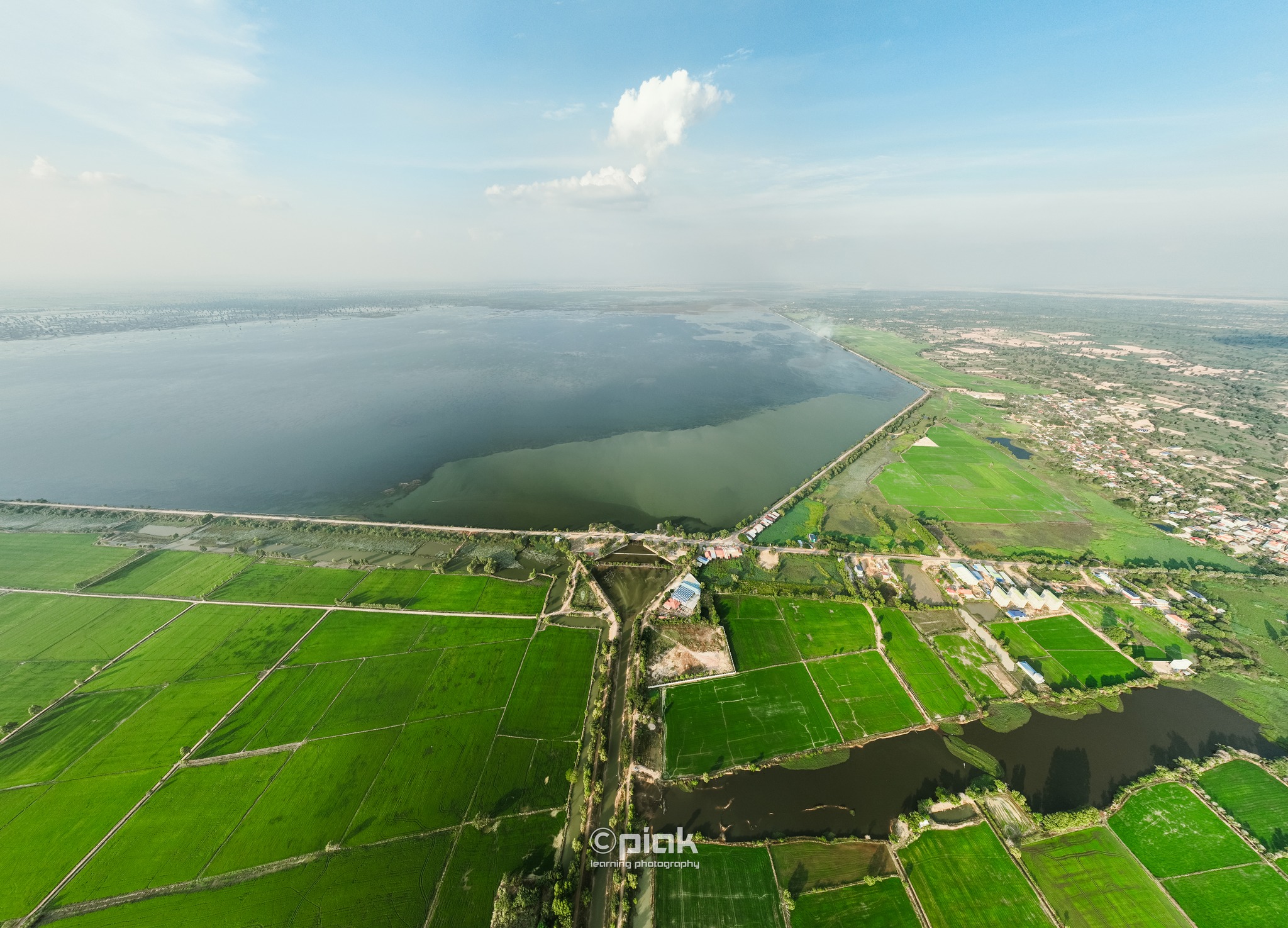
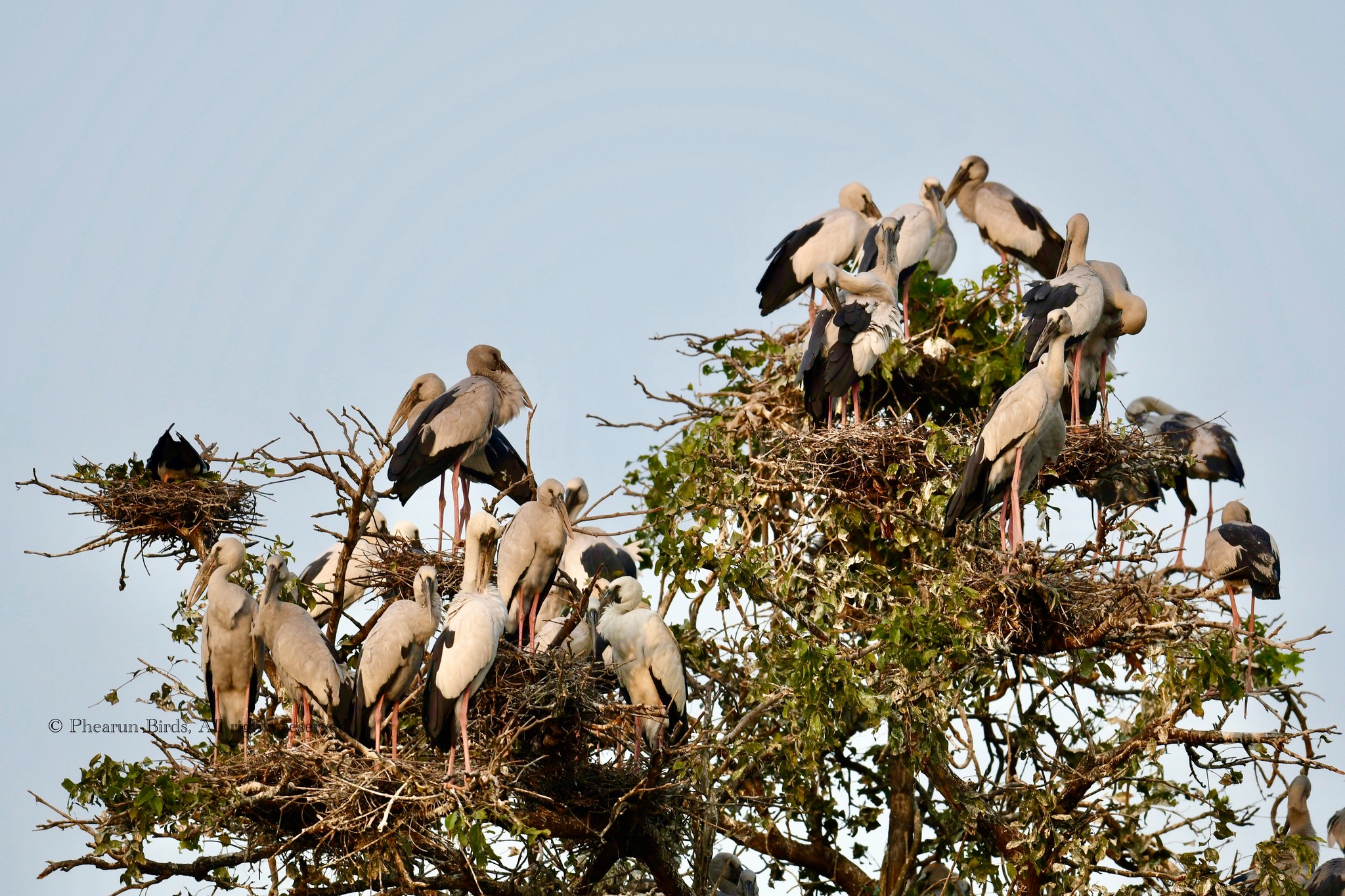
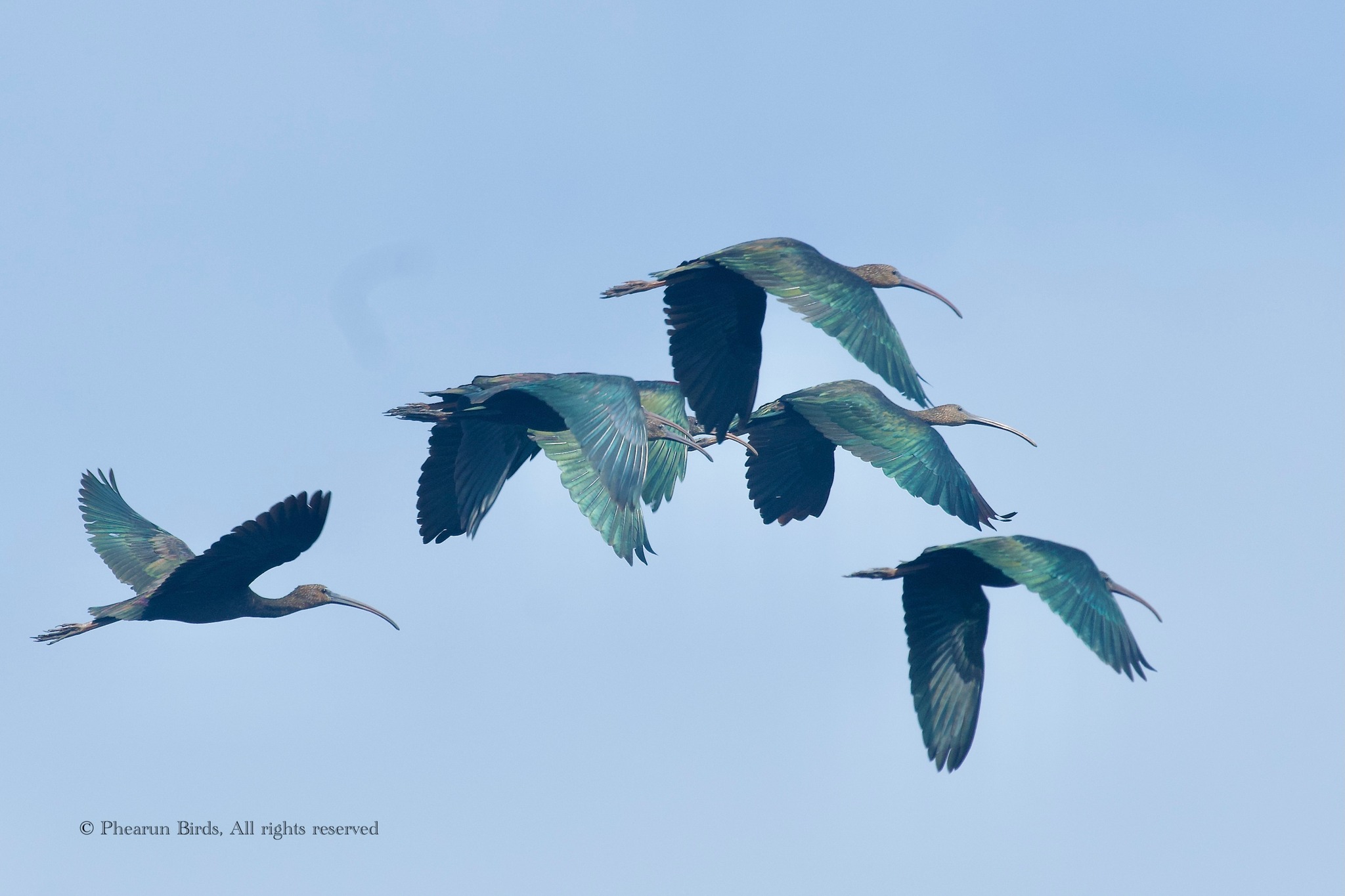
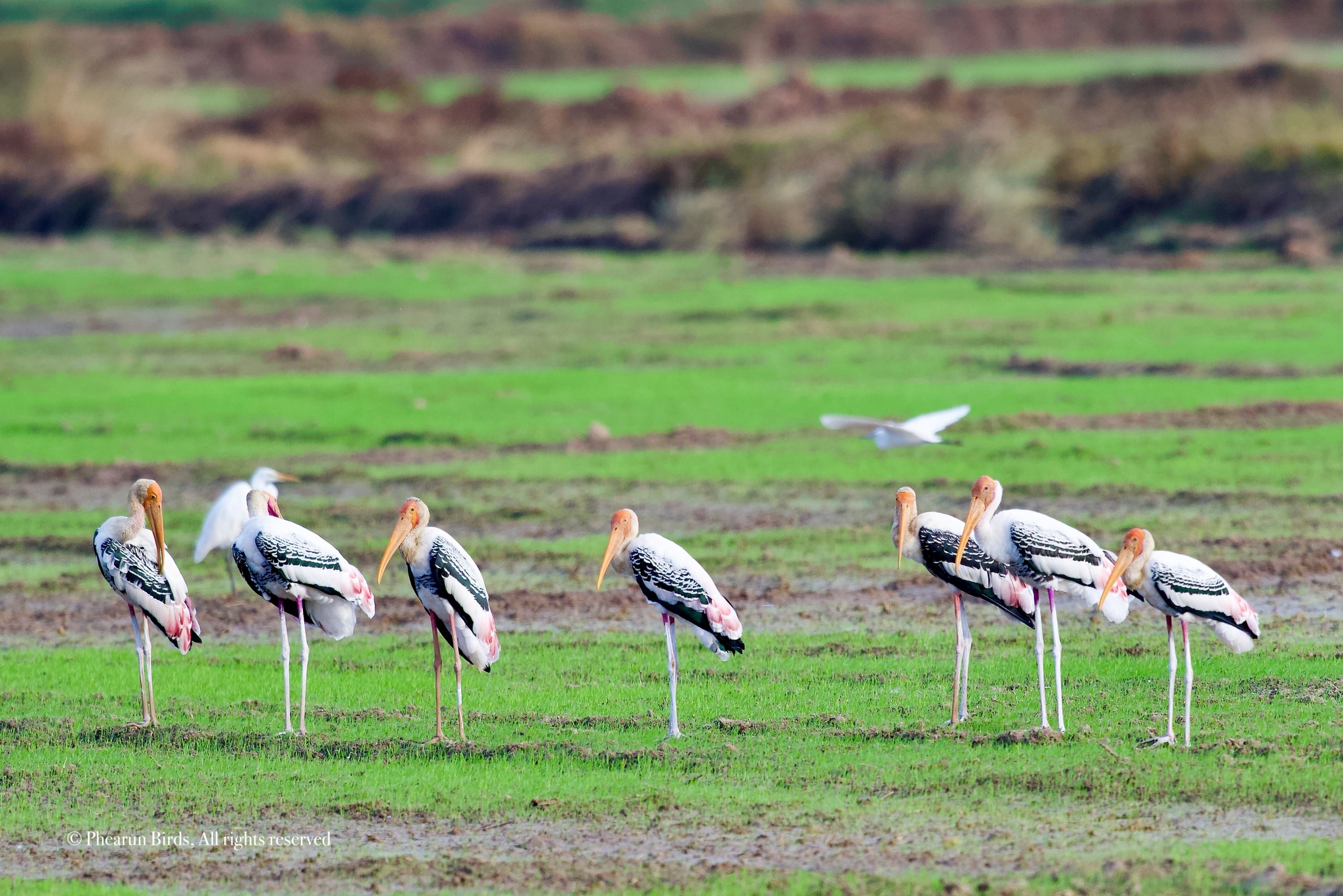
Ang Trapeang Thma is a vital wetland sanctuary in Banteay Meanchey that serves as a premier habitat for the endangered Sarus Crane and over 200 other diverse bird species. The landscape is centered around a massive ancient Khmer reservoir that was expanded under the Khmer Rouge regime and has since transitioned into a critical refuge for rare wildlife, including the Eld’s deer. Today, the site represents a powerful intersection of history and nature, offering a serene environment where birdwatchers can witness the resilience of Cambodia’s ecological heritage.

Phnom Srok Golden Silk Production
- Location: Phnom Srok District
- Entrance Fee: Free
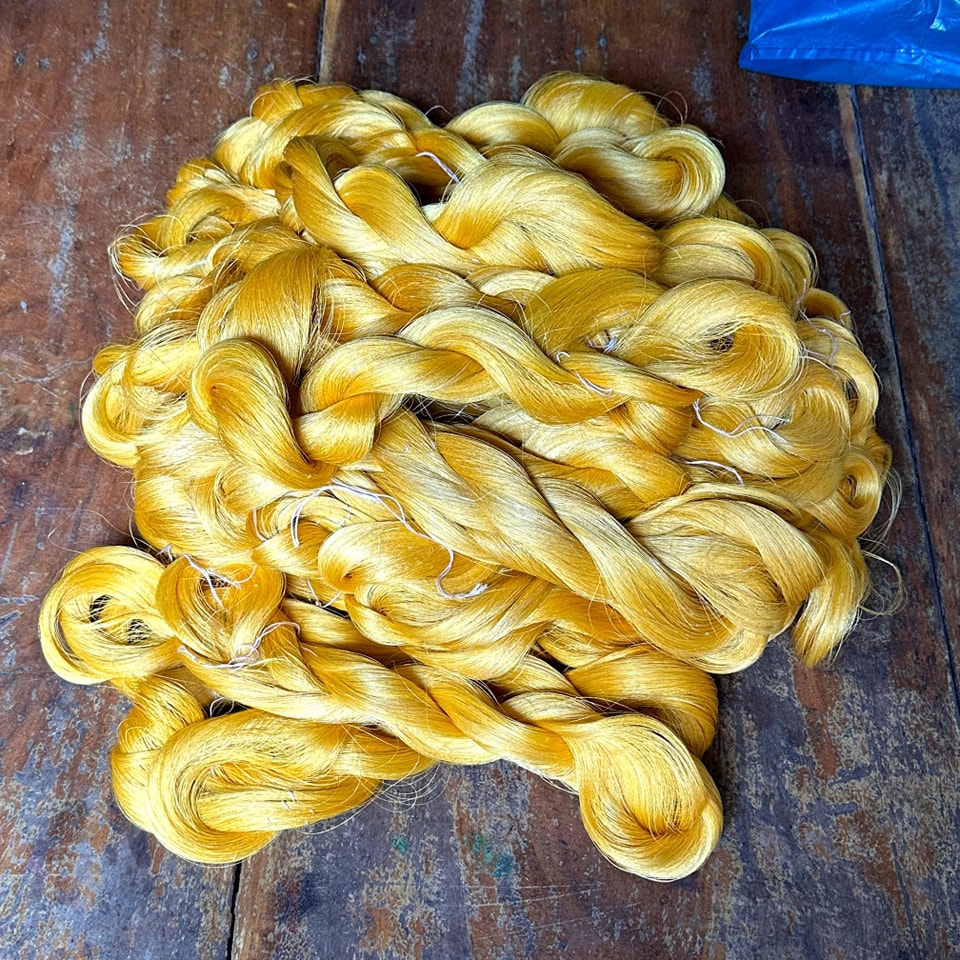
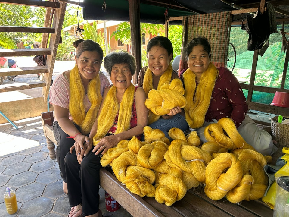
The artisans of Phnom Srok meticulously maintain the entire lifecycle of golden silk production, from cultivating mulberry trees to feeding silk moths to hand-reeling the naturally shimmering yellow cocoons. These vibrant threads are woven on traditional wooden looms, resulting in high-luster fabrics that are world-renowned for their unique shimmering quality and durability. Now officially recognized as a Protected Geographical Indication (GI), this artisanal craft is a legally protected heritage that honors the specific regional expertise and geographical environment unique to the province.

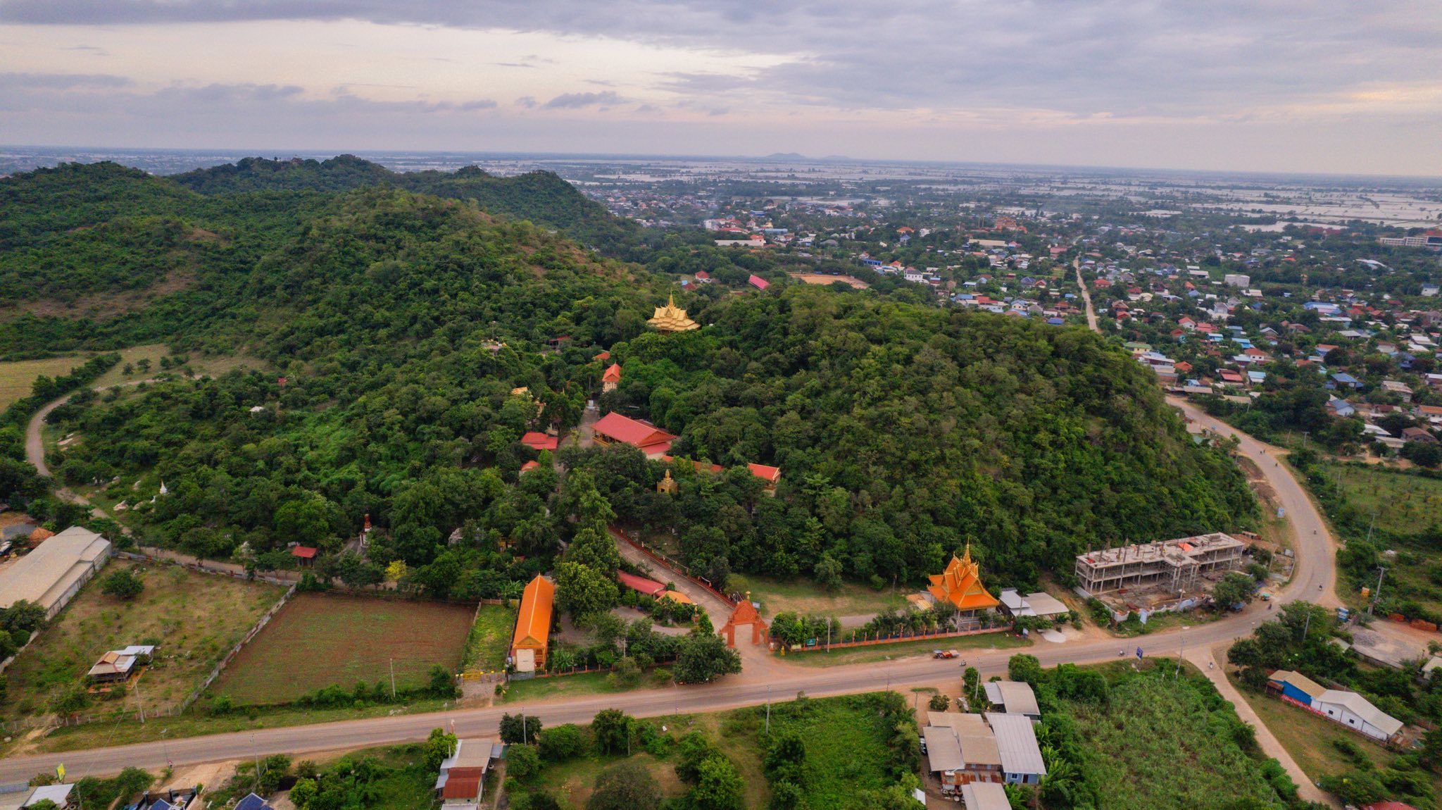
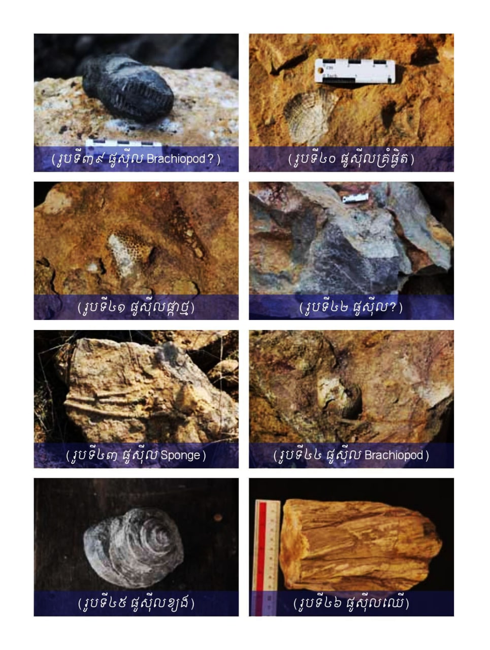
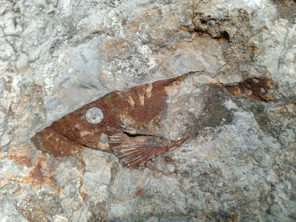
Find Sea Fossils at Limestone Mountains
- Location: Serei Sophorn
- Entrance Fee: Free
The limestone massifs surrounding the provincial capital, including Phnom Chingchiang and Phnom Kangva, serve as a geological window into a prehistoric marine world dating back nearly 260 million years to the Permian era. At sites such as Phnom Bak, Phnom Kantout, and Phnom Svay, researchers and visitors have discovered fossilized remains of ancient corals, brachiopods, and rare fish embedded directly within the sedimentary rock layers. These prehistoric treasures offer a striking contrast to the modern rice plains, providing tangible evidence that this northwestern frontier was once submerged beneath a vast and vibrant ancient sea.

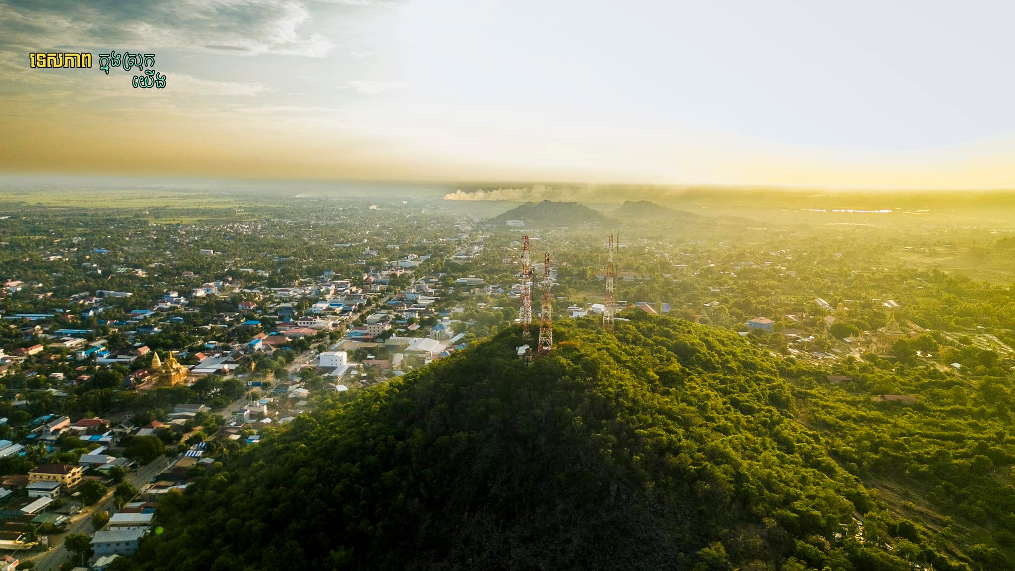
Daily Life at Poipet and Serei Sophorn
- Location: Poipet & Serei Sophorn
- Entrance Fee: Free
Poipet offers a high-energy introduction to the province as a modern trade gateway, where the National Road 5 connects bustling border markets to sleek new entertainment complexes. In contrast, the provincial capital of Serei Sophorn serves as the region’s cultural soul, inviting you to explore the local livelihood or climb the staircase of Wat Phnom Svay for panoramic views of the surrounding plains. Together, these two cities provide a perfect balance between Cambodia's fast-paced frontier ambition and the grounded, traditional rhythm of its historic heartland.
