
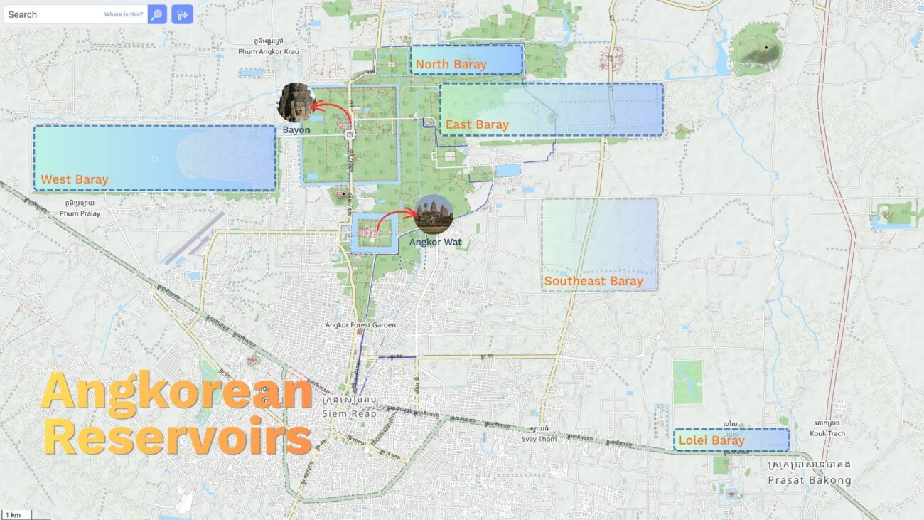
Long before engineers had machines to move earth, the Khmer people of Angkor moved mountains of it with nothing but baskets, oxen, and sheer will. Scattered across the Angkor Archaeological Park are four enormous rectangular basins known as barays — the Khmer word for reservoir — each one a monument not of stone, but of soil and water. They rank among the largest hydraulic works of the pre-industrial world, and one of them, the West Baray, is still counted among the largest hand-dug water reservoirs on Earth.
To stand on the crest of one of these ancient dikes today, watching fishermen cast their nets or children splashing at sunset, is to stand on top of an engineering achievement over a thousand years old — one that still holds water in the 21st century.
What Exactly Is a Baray?
A baray (Khmer: បារាយណ៍ and taṭāka/តដាក/तटाक in Sanskrit; sometime known as rahal/រហាល) is an artificial reservoir, rectangular in plan and oriented along the cardinal directions, enclosed by massive earthen embankments. Unlike a simple irrigation pond, a baray at Angkor was a statement — of royal power, of religious cosmology, and of a civilization’s mastery over its environment.
Historians have long debated their purpose. The traditional view, championed by French archaeologist Bernard-Philippe Groslier in his theory of Angkor as a “hydraulic city,” held that the barays were the beating heart of a vast irrigation network, storing monsoon water to feed rice fields through the dry season and enabling the multiple harvests needed to sustain a population that may have reached three-quarters of a million people at its height. It was this agricultural surplus, in this reading, that funded the temples, armies, and god-kings of the empire.
More recent scholarship complicates that picture. Excavations have not turned up the extensive irrigation canal systems one might expect if the barays were purely agricultural infrastructure, and some barays appear only loosely connected, if at all, to the rice fields around them. This has led many scholars toward a second, complementary explanation: that the barays were primarily sacred geography. In Hindu cosmology, the universe is arranged around Mount Meru, the axis of the world, surrounded by a cosmic ocean. Angkor’s kings, who ruled as devarajas — god-kings — built their empire as a physical model of this cosmic order. A baray, with a temple-mountain rising from an island at its center, was the Sea of Creation given earthly form, and the temple upon it was Meru itself.
The truth, as is so often the case, likely lies in both directions at once: practical water management wrapped in the architecture of the sacred, each reinforcing the authority of the other.
Indratataka: The First Great Reservoir (ឥន្ទ្រតដាក ឬបារាយណ៍លលៃ)
The story of Angkor’s barays does not actually begin at Angkor. It begins at Hariharalaya, the earlier Khmer capital near modern Roluos, a short drive southeast of Siem Reap. Here, King Indravarman I began construction of the Indratataka — “the reservoir of Indra” — on the fifth day after his coronation, according to a Sanskrit inscription that has survived to this day. Completed under his son and successor, Yasovarman I, around 889 CE, the Indratataka measured roughly 3.8 by 0.8 kilometers and held an estimated 7.5 million cubic meters of water at capacity — enough to fill roughly 3,000 Olympic swimming pools.
At its center, Yasovarman I built the temple of Lolei, dedicated in 893 CE to the memory of his royal ancestors, particularly his father. Positioning a temple honoring Indravarman at the very heart of the reservoir Indravarman himself had commissioned was no accident — it fused ancestor worship, dynastic legitimacy, and cosmology into a single, deliberate act of architecture. The four brick towers of Lolei still stand today, though the great reservoir around them has long since dried into farmland and forest, leaving the temple looking almost stranded on what was once a ceremonial island.
Yashodharatataka: The East Baray (យសោធរតដាក ឬបារាយណ៍ខាងកើត)
Almost immediately after founding his new capital of Yashodharapura — centered on Phnom Bakheng, a few kilometers from Hariharalaya — Yasovarman I began an even more ambitious reservoir: the Yashodharatataka, known today as the East Baray. At roughly 7.8 by 1.8 kilometers, it dwarfed the Indratataka nearly fivefold and marked the moment barays shifted from royal commemoration to the very organizing principle of the Angkorian capital. At an estimated 36 to 37 million cubic meters of capacity, it could have filled close to 15,000 Olympic swimming pools.
About fifty years after its completion, King Rajendravarman built the East Mebon at its center, dedicated in 953 CE to Shiva and to the memory of the king’s parents — its sandstone lions and elephant sculptures remain among the most striking at Angkor. The East Baray is now entirely dry, its vast rectangular footprint visible mainly from the air or in the gentle, telltale flatness of the surrounding rice paddies, still faintly outlined by the ghost of its ancient dikes.
West Baray: The Largest Hand-Dug Reservoir on Earth (បារាយណ៍ទឹកថ្លា ឬបារាយណ៍ខាងលិច)
If Indratataka was the first experiment and the East Baray the proof of concept, the West Baray was the masterpiece — and it remains, even now, one of the largest reservoirs ever excavated by human hands anywhere in the world.
Construction most likely began in the 11th century under Suryavarman I and was completed under his successor, Udayadityavarman II. The numbers alone are staggering: the West Baray measures approximately 7.8 by 2.1 kilometers, enclosed by earthen dikes standing roughly 12 meters (about 39 feet) high. At full capacity, it can hold somewhere between 12 and 14 billion gallons — around 53 million cubic meters — of water. To put that scale in perspective, the entire reservoir was dug and its embankments raised without a single wheelbarrow, hydraulic pump, or beast of burden more advanced than an ox-cart, using organized labor on a scale that must have drawn on communities across the empire.
A more tangible way to grasp that volume: an Olympic swimming pool holds about 2,500 cubic meters of water. The West Baray, at its historic full capacity, could have filled roughly 21,000 of them — a number that puts even its own record-holding scale into sharper focus.
Remarkably, the Angkorian builders didn’t start from a blank slate. The eastern dike appears to incorporate an earlier embankment that once enclosed Yasovarman I’s capital around Phnom Bakheng, and in the southern dike lies a partially buried gem of Khmer architecture: Ak Yum, a brick pyramid temple dating to as early as the 7th or 8th century — centuries older than Angkor Wat itself, and effectively swallowed by the later reservoir. Excavations along the baray’s western floor have also uncovered wall foundations, steps, and pottery shards, along with an inscribed stele dated to 713 CE, hinting that this land was inhabited long before it was flooded to become a royal reservoir.
At the center of the West Baray sits the West Mebon, a Hindu temple built on an artificial island and reachable today only by boat. It was here, in the mid-20th century, that archaeologists recovered one of the finest bronze sculptures to survive from the Angkorian era: a monumental reclining figure of Vishnu, believed to have once floated symbolically on the cosmic ocean the baray itself was built to represent.
Unlike its siblings, the West Baray never fully dried out. It still holds water year-round, fed by seasonal rains and, in modern times, by a regulator connected to the Siem Reap River. Today it functions as both an irrigation source for surrounding farmland and a beloved local escape — a place where Siem Reap families come to swim, share a meal on the water’s edge, and watch the sun set over dikes their ancestors raised nearly a thousand years ago.
Jayatataka: The Sacred North Baray (ជយតាដាក ឬបារាយណ៍នាគព័ន្ធ បារាយណ៍ខាងជើង)
The fourth and final great baray belongs to a different era and a different vision of kingship. Built in the late 12th century under Jayavarman VII — the prolific builder-king behind Angkor Thom, the Bayon, and Ta Prohm — the Jayatataka (“victory reservoir”) measured about 3.5 by 0.9 kilometers and served as the baray of the nearby temple complex of Preah Khan. Its storage capacity is estimated at somewhere between 8.7 and 10 million cubic meters depending on the phase of construction — equivalent to roughly 3,500 to 4,000 Olympic swimming pools, modest next to the West Baray but still a formidable feat for a single reign.
At its heart lies Neak Pean, “the entwined serpents,” one of the most unusual and beloved structures in the entire Angkor complex. A circular central pond, said to represent the mythical Himalayan lake Anavatapta whose waters were believed to cure all illness, is surrounded by four smaller pools, each connected by a carved spout in the shape of an animal — elephant, horse, lion, and human — representing the classical elements of earth, wind, fire, and water. Pilgrims and the sick would reportedly bathe in these pools seeking healing, making Neak Pean, alongside the nearby hospital chapels Jayavarman VII built across his empire, part of a broader Buddhist project of compassionate public works.
An inscription at Preah Khan makes the symbolism explicit and rather audacious: it claims the waters of the Jayatataka were holier than those of Prayag, the sacred confluence of the Ganges and Yamuna rivers in India. Together with the East Baray, dedicated to Shiva, and the West Baray, dedicated to Vishnu, the inscription frames Jayavarman VII’s new Buddhist reservoir as Angkor’s third great sacred water — a claim that Angkor’s cosmic geography rivaled, and perhaps surpassed, that of India itself.
The Southeast Baray: Angkor’s Forgotten Reservoir (បារាយណ៍អាគ្នេយ៍)
Not every baray at Angkor became a household name, and one of the quietest is the so-called Southeast Baray, believed to have been built during the reign of Jayavarman VII in the late 12th century, alongside his other great hydraulic and religious works. Unlike the West Baray or Jayatataka, the Southeast Baray never became a magnet for temple-builders, inscriptions, or later tourism, and it has consequently received far less archaeological attention than its three famous siblings. What little is known comes largely from aerial and LiDAR survey work rather than from grand inscriptions or well-preserved masonry, and its precise dimensions, capacity, and function remain far less settled in the scholarly record than those of the West Baray or East Baray.
Today the Southeast Baray, like the East Baray and Indratataka before it, has dried out completely, its ancient bed long since reclaimed by vegetation, rice paddies, and rural settlement. It stands as a useful reminder that the story of Angkor’s water system is not limited to the four great, well-documented barays alone — the Greater Angkor landscape is dotted with smaller, lesser-known basins, ponds, and embankments still awaiting the kind of systematic study that has illuminated their larger counterparts. For every baray whose history is filled with kings, inscriptions, and temples, there is likely another whose story has simply not yet been told.
Beyond Angkor: The Rahals of Koh Ker, Banteay Chhmar, and Preah Khan of Kampong Svay (រហាល)
The baray was never an Angkor-only idea. Khmer kings built the same royal water monument wherever they built a capital or a major provincial city, and three of the clearest examples of this lie well outside the Angkor Archaeological Park: the Rahals of Koh Ker, Banteay Chhmar, and Preah Khan Kampong Svay.
Koh Ker. When King Jayavarman IV abruptly moved the Khmer capital some 120 kilometers northeast of Angkor to the remote site of Koh Ker in 928 CE, he brought the baray tradition with him. Within his brief but frantic 16-year building program — nearly 40 temples, a soaring seven-tiered pyramid, and an entire new city — he raised the Rahal, a reservoir measuring roughly 1,200 by 560 meters. It is modest next to the West Baray, but by some accounts it was the largest reservoir in the Khmer Empire at the time it was built, years before the East Baray at Angkor would eclipse it. The Rahal breaks from the classic Angkor template in a telling way: rather than running strictly east-west, it is oriented along a north-northwest to south-southeast axis, following the natural lay of the land rather than pure cardinal cosmology, and some archaeoastronomers argue its alignment tracks a specific solar azimuth rather than the mandala geometry seen at Angkor. Recent surveys have also uncovered a massive spillway and discharge chute engineered to handle the reservoir’s overflow — evidence, some researchers now believe, that the Rahal’s failure or overtopping may have been a factor in Koh Ker’s abandonment as capital after little more than a decade and a half, a sobering reminder that even the Khmer’s finest hydraulic engineering had its limits.
Banteay Chhmar. Some two centuries later, Jayavarman VII — the same tireless builder-king behind Angkor Thom, Preah Khan, and Neak Pean — raised a second city far in Cambodia’s remote northwest, near the modern Thai border, to honor his son Prince Srindrakumara and the royal guards who died defending him. Banteay Chhmar’s own Rahal, lying east of the temple and measuring roughly 1.6 by 0.8 kilometers, follows the familiar Angkorian pattern far more closely than Koh Ker’s does: a rectangular basin on the temple’s axis with a Mebon, or island shrine, rising from its center, once reached by boat from a landing stage on the reservoir’s western edge. In miniature, it repeats the exact symbolic arrangement of the East and West Mebon at Angkor — temple-mountain rising from the cosmic sea — transplanted to a frontier city hundreds of kilometers from the capital. Like so many of its Angkor cousins, the Banteay Chhmar Rahal is dry today, and the wider temple complex remains one of the least excavated and least understood major sites from the Angkorian period, its bas-reliefs and hydraulic works still only partially studied.
Together, these two reservoirs make an important point about the barays as a whole: they were not a quirk unique to the Angkor plain, but a recurring instrument of Khmer kingship itself — proof that wherever an ambitious king built a new capital, a baray was expected to rise beside it, whether that capital lasted five centuries, like Angkor, or barely sixteen years, like Koh Ker.
Preah Khan of Kampong Svay. Roughly 100 kilometers east of Angkor, in present-day Preah Vihear province, lies Prasat Bakan, better known as Preah Khan of Kampong Svay — the largest single walled religious complex ever built in the Angkorian era, its outer enclosure sprawling across some 22 to 25 square kilometers. Unusually, construction here spanned multiple reigns rather than a single king’s building program, beginning under Suryavarman I in the 11th century, continuing under Suryavarman II, and reaching its final form under Jayavarman VII in the early 13th century — making its baray one of the longest works-in-progress of any reservoir in the empire.
That baray, known locally as Trapeang Pradak, measures roughly 2.8 to 3 kilometers by 0.5 to 0.75 kilometers, putting it in the same length class as the East Baray, though considerably narrower. It breaks from the standard Angkorian template in a way that echoes Koh Ker: rather than the customary east-west orientation, the complex and its reservoir are aligned closer to a north-south axis. At its center sits Preah Thkol, a cruciform sandstone Mebon temple on an artificial island, the familiar temple-rising-from-the-cosmic-sea arrangement seen at the East Mebon, West Mebon, and Banteay Chhmar. On the reservoir’s southeast bank stands Prasat Damrei, the “Elephant Temple,” a 15-meter laterite pyramid crowned with carved stone elephants at its corners, watching over the water from its edge much as Ak Yum once watched over what became the West Baray.
Today the baray is almost entirely dry and given over to farmland, though its northern stretch still holds water and is known locally as the Preah Dac Baray. Some scholars have floated an intriguing, unproven theory that Preah Khan of Kampong Svay and Banteay Chhmar together formed part of a symbolic mandala of satellite cities radiating outward from the Bayon at the heart of Angkor — a reminder that even Cambodia’s most remote and least-visited Angkorian ruins may still have been understood, in their own time, as part of one connected sacred geography.
One Pattern, Many Names: The Island Temple at the Heart of Every Baray
Look past the individual histories of each reservoir, and a striking pattern emerges: nearly every major baray in the Khmer world was built around the same core idea — a temple rising from an artificial island at its exact center, reachable only by boat or causeway. The temple is not always called a “Mebon មេបុណ្យ” (the name properly belongs to just two of them, the East Mebon and West Mebon), but the underlying concept repeats itself again and again across three centuries and hundreds of kilometers: Lolei rising from the Indratataka, the East Mebon from the East Baray, the West Mebon from the West Baray, Neak Pean’s shrine from the Jayatataka, Preah Thkol from the Trapeang Pradak at Preah Khan of Kampong Svay, and a smaller Mebon shrine from the Rahal at Banteay Chhmar. Different kings, different reigns, different names for the temple — yet the same essential composition, repeated as a kind of signature move of Khmer sacred architecture: cosmic mountain rising from cosmic sea, king’s ancestors or chosen deity enshrined at the exact center of the kingdom’s most monumental engineering project.
It’s a detail easy to miss precisely because it recurs so consistently — most visitors experience these temples in isolation, without realizing that “an island shrine at the center of a giant reservoir” was practically a required feature of any self-respecting Angkorian-era baray, not a one-off flourish.
The single most extraordinary object to emerge from this pattern came from the West Mebon. In 1936, conservators excavating the ruined temple recovered fragments of an enormous bronze sculpture — a reclining figure of Vishnu Anantasayin, the god asleep upon the cosmic ocean between cycles of creation, dreaming the universe into being from his navel. Painstakingly reassembled, the figure is believed to have originally stretched some six meters in length, making it one of the largest bronze sculptures known to have survived from the ancient world, and very likely the largest of its kind produced anywhere at the time it was cast. Its placement could not have been more fitting: a sleeping Vishnu, generating the universe upon the cosmic sea, set inside a temple on an island, set inside an artificial lake built to represent that very same cosmic sea. Few objects anywhere illustrate so directly how literally the Khmer intended these reservoirs to be understood — not simply as engineering, but as the ocean of creation itself, built by human hands and populated with its own resident god. The surviving fragments of the bronze are now held at the National Museum of Cambodia in Phnom Penh (temporarily displayed at Smithonian’s National Museum of Asian Art from March 7–September 7, 2026), where the sheer scale of even the reassembled remnant still startles visitors used to Angkor’s stone-carved gods rather than its cast bronze ones.
Where the Water Went: From Reservoirs to Rice Fields
Walk the dry bed of the East Baray, the Indratataka, the Jayatataka, or the Southeast Baray today, and it is easy to miss that you are standing inside a reservoir at all. Grass grows where water once stood 12 meters deep. Rice paddies checkerboard the old basin floors. Small villages, their houses raised on stilts from old habit more than current necessity, sit directly atop what were once the engineered floors of royal water infrastructure. This transformation — from sacred hydraulic monument to ordinary farmland — did not happen overnight, and it is as much a part of the barays’ story as their construction.
Scholars now believe the decline unfolded gradually, through a combination of factors rather than a single dramatic collapse. Centuries of sediment carried in by rivers and monsoon runoff slowly filled the reservoirs, reducing their depth and volume; by the time Jayavarman VII modified the older Srah Srang basin around 1200, the East Baray had reportedly already become overwhelmed by silt and was failing at its original function. Maintaining a system on this scale — the reservoirs, but also the vast, interconnected web of canals, moats, spillways, and embankments that fed and drained them — required constant, coordinated labor, and evidence shows episodes of breakdown and repair throughout the Angkorian period even at the height of the empire’s power. When the kingdom’s political and economic center of gravity shifted, and especially after Angkor’s gradual decline and eventual abandonment as the capital in the 15th century, that maintenance simply stopped.
Climate appears to have delivered the final blow. Tree-ring and sediment studies point to a period of severe, prolonged drought interrupted by intense monsoon flooding in the 14th and 15th centuries, a punishing one-two combination that a weakened and undermaintained hydraulic network could no longer absorb. Canals silted up permanently, dikes breached and were never repaired, and reservoirs that had held water for centuries began drying out for good. Nature, and eventually people, moved back in: forest reclaimed the smaller channels first, while the open, cleared expanses of the old baray floors — flat, fertile, and already leveled by ancient engineers — proved irresistible to farmers over subsequent centuries. Villages like Preah Dak, on the old bed of the East Baray, and countless unnamed hamlets on the floors of the Indratataka, the Southeast Baray, and beyond, sit today on ground their occupants likely never knew was once a royal reservoir.
It is a quietly poignant irony: the same flat, well-drained, silt-enriched land that made these sites attractive to Angkorian engineers for water storage a thousand years ago is exactly what makes them attractive to farmers today. The barays’ second life, as rice fields and villages, is in its own way a continuation of the very purpose — feeding people — that many scholars believe partly motivated their construction in the first place.
An Empire’s Legacy, Now Beneath Rice Fields and Villages
Taken together, the barays of Angkor tell the story of an empire that grew, century by century, in scale of ambition: from Indravarman’s modest royal gesture, to Yasovarman’s city-defining reservoir, to Suryavarman’s almost unfathomable West Baray, to Jayavarman VII’s final, deeply personal act of Buddhist devotion. Each reservoir reflects the king who built it, and each remains legible in the landscape today — dry and grassed over at Lolei and the East Mebon, half-forgotten under the earth at Ak Yum, or still shimmering with water at the West Baray, exactly as it has for nearly a millennium.
Modern hydrological surveys using LiDAR have only deepened appreciation for what the Khmer engineers achieved, revealing a far denser web of canals, ponds, and water channels stretching for kilometers beyond the barays themselves — a hydraulic landscape on a scale that took Western archaeologists decades to fully grasp, precisely because so much of it was invisible from the ground, hidden beneath centuries of forest.
The barays are, in the end, Angkor’s quietest monuments. They carry none of the intricate bas-reliefs of Angkor Wat or the serene stone faces of the Bayon. Their grandeur is written instead in scale, in the sheer, almost incomprehensible volume of earth moved by hand — a reminder that the Khmer empire’s greatest achievements were not only carved in stone, but dug into the ground itself.
And yet, for all that has been uncovered, far more remains unknown than known. No Angkorian engineering manual has ever been found; no inscription explains how the builders surveyed 7.8 kilometers of dead-level dike with such precision, how they calculated capacity, timed construction around the monsoon, or organized and fed the labor force needed to move millions of cubic meters of earth by hand. The techniques that let a medieval Khmer kingdom out-engineer most of its contemporaries were never written down for us to inherit — they were passed hand to hand, generation to generation, and were largely lost when the hydraulic system itself fell into disuse. What is understood today about the barays and Angkor’s wider water network is thanks to relatively recent tools — LiDAR surveys, sediment coring, satellite imagery — and even these have only scratched the surface of a system covering roughly 1,000 square kilometers. Lesser-known sites like the Southeast Baray, and countless smaller ponds, canals, and embankments still hidden under forest and farmland, remain understudied simply for lack of funding, personnel, and time. Recovering more of this lost engineering knowledge, and properly protecting the sites that still hold its evidence, will take sustained investment in Cambodian-led archaeology and hydrology — an investment as much in the country’s future as in its past.